Physical Geography of Alberta
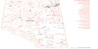
The highest point in the province is Mt. Columbia on the B.C.-Alberta border at the head of the Athabasca River, whose summit is 12,294 ft. above sea level.1 The nearest approaches to sea level are at the point where the Slave River crosses into the Northwest Territories,2 and about 20–25 miles west-southwest of there, in a low hay and swamp meadow including what is identified on the map as St. Bruno Farm, both of which are below 600 ft.3 The Slave River descends in a series of rapids from the Pelican to the gruesomely named Rapids of the Drowned. Lake Athabasca, which is drained to the north by the Slave River, is about 700 ft. above sea level.4
Several remarkable rises appear in the landscape east of the Rocky Mountains. The Cypress Hills in the southeast rise nearly 2000 ft. above the surrounding terrain,5 enough to have avoided being glaciated in their upper reaches.6 This has resulted in an island of flora and fauna which is a mix of species found 150 miles west in the Rocky Mountains, and others which are unusual for such a northerly latitude.7 The Swan Hills, south of Lesser Slave Lake, the Clear Hills, north of the Peace River and east of the British Columbia boundary, and the Caribou Mountains in the far north of the Province, all rise over 1500 ft. above their surroundings with peak elevations of about 4300 ft., 3500 ft., and 3200 ft. respectively.8
The Province extends geographically from 49° to 60° North, the equivalent of Paris to the southern part of the Shetland Islands, from Stuttgart to Oslo, or from Poltava to St. Petersburg. The climate is more akin to, though more severe than the last of these three, sheltered from the moderating influence of the Pacific Ocean by 500 miles of mountainous terrain.
The natural vegetation of the northern three quarters of Alberta is dominated by Aspen Poplar, which only in recent times has become an economically important resource. In its southern reaches, it occurs in association with grasses that creates what is termed a Parkland region. White spruce, lodgepole pine and jackpine occur in mixed stands on higher ground in the foothills and mountain regions and on most uplands of central and northern Alberta. Black spruce and sphagnum moss, both of which have also found recent economic uses, occupy lower lying and wet upland areas.9
Grasslands occupy the southern quarter of the Province east of the mountains and foothills. Over fifty percent of the grasslands and Aspen Poplar Parkland and forest region south of an east-west line half way between Edmonton and Athabasca, and east of a curving north-south line from Barrhead to Gull Lake to Cochrane and Pincher Creek, have been brought under cultivation.10 A similar pattern of clearing the Parkland began in the Grande Prairie and Peace River districts in the decade between 1910 and 1920,11 and continues today in one of the few areas left where a person can ”homestead.”
On the high prairie, or short grass prairie of Southern Alberta, a continual shortage of moisture12 results in frequent soil drifting. This may occur in winter, as well as summer, if snowfall is not adequate to cover fields left barren after harvest or if Chinooks remove the snow cover. The only reliable sources of water are the rivers descending from the Rocky Mountains,13 providing water for cattle and water for crop agriculture, the latter through extensive irrigation systems.
The rivers of Alberta drain to the south, the east, and the north. The Milk River Basin eventually becomes a part of the Missouri-Mississippi and empties into the Gulf of Mexico. The Bow and Saskatchewan Basins join the Nelson River and empty into Hudson Bay. The Athabasca and Peace River Basins become part of the Slave and Mackenzie system and thereby reach the Arctic Ocean.
Notes | Bibliography | Abbreviations
1. Atlas of Alberta, Plate 10–11 (Edmonton: The University of Alberta, 1969).2. National Topographic System, 1:250,000 series, sheet 74M, 3rd ed., 1967.
3. Ibid., sheet 84P, 3rd ed., 1967. The area noted is about 73.5 sq. mi. along the Salt River and Brine Creek.
4. Ibid., sheet 74M, 3rd ed., 1967.
5. National Topographic System, 1:500,000 series, sheet 72NW(S ½)[&]72SW(N ½), 6th ed., 1973.
6. Atlas of Alberta, Plate 12.
7. Charles D. Bird, and Ian A.R.Halladay, “The Cypress Hills,” in W.R. Hardy, Alberta: A Natural History (Edmonton: The Patrons, 1967), p. 120.
8. National Topographic System, 1:500,000 series, sheets 83NE, 5th ed., 1978; 84SW, 6th ed., 1973; 84NE, 5th ed., 1964.
9. Atlas of Alberta, Plate 28–29.
10. Ibid.
11. Howard Palmer and Tamara Palmer, Alberta: A New History (Edmonton: Hurtig, 1990), p. 150.
12. Atlas of Alberta, Plate 19.
13. Robert Green, and Arleigh H. Laycock, “Mountains and Plains,” in Hardy, p. 87.