Land Grant System
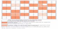
The Dominion Lands Survey of 1871 was a rectangular system adopted from the United States and adapted to the Canadian scene.1 It consisted of a series of astronomically determined initial meridians and base lines. To the prime meridian (97° 27' 28.4") just west of Winnipeg was added a series of initial meridians—the fourth being the border, between Saskatchewan and Alberta—four degrees of longitude apart starting with the second, which was 4° 32' (102°W) 31.6" from the prime. The initial base line was the Canada-United States border with subsequent base lines established four Townships apart. The curvature of the earth required corrections to the range lines. Thus a grid of east-west township lines numbered from the international border, and north-south range lines numbered from an initial meridian established a network of Townships each approximately six miles square comprising 36 sections. Each section was subdivided into quarter sections of 160 acres, commonly referred to as a homestead.2

This rigid system was adopted because of its simplicity, accuracy and speed of execution.3 However, there were disadvantages. Distances were longer than if the road allowances had been adapted to the topography.4 This pattern also tended to scatter the population resulting in feelings of isolation and subsequent loneliness.5 As a solution to this problem William Van Horne, President of the Canadian Pacific Railway, proposed a radial scheme for a Township without disturbing the overall network, but nothing was done to implement his idea.6
It was upon this rectangular pattern that the land was granted for settlement and the building of railways. At the transfer in 1870 the Hudson’s Bay Company had been allotted no more than 50,000 acres around each post and one 20th of the land in the fertile belt.7 This meant that this company received sections 8 and three quarters of 26 (the whole of 26 in each 5th Township). Two other sections, 11 and 29, were set aside as school endowments.8
As part of the contract for building the railway to the Pacific coast in British Columbia, the Canadian Pacific Railway Company was granted 25,000,000 acres, to be selected from the odd-numbered sections (excluding the school lands) in a belt of land 24 miles on each side of the main line. Unlike the American scheme whereby railway companies had to accept all alternate sections on each side of the main line irrespective of the quality of the land, the contract with the CPR specified that the land must be “fairly fit for settlement.” If there was insufficient land (as there was when the CPR abandoned the original designated line from Winnipeg to Jasper House) within the 48-mile belt to meet this criterion the CPR could and did patent land in the fertile belt outside the mainline corridor.9

This same stipulation was granted to branch lines and later to those known as “colonization” railways.10 The even-numbered sections were to be set aside as free homesteads.
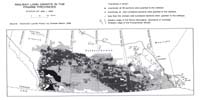
Part of the deficiency was made up by the CPR accepting a large block of land comprising all the odd- and even-numbered sections, including school lands, other than the Hudson’s Bay Company lands between Medicine Hat and Calgary, which came to be known as the Irrigation Block.11 By exchange with and purchase by the CPR the HBC relinquished its claims in this area.12
Eventually, beside the grants to the HBC and other groups, over 31 million acres of land were taken up by the various railways, mostly from the future provinces of Saskatchewan and Alberta.13
The land grant system had become thoroughly discredited in the United States by the time the Canadian government adopted it.14 The last of the statutory land grants to railways in Canada were made in 1894.15 The last of the railway lands were not patented until the early part of the 20th century. In the Dominion Lands Act of 1908 the land grant system was ended.16
Notes | Bibliography | Abbreviations
1. C. Martin, “Dominion Lands” Policy, Carleton Library No. 69 (Toronto: McClelland and Stewart, 1973).2. R.B. McKercher and B. Wolfe, Understanding Western Canada’s Dominion Land Survey System (Saskatoon: University of Saskatchewan, 1986), pp. 1–11.
3. T. Adams, Rural planning and development: A study of rural conditions and problems in Canada (Ottawa: Commission of Conservation, 1917), pp. 45–46.
4. Ibid., p. 58
5. Ibid.
6. Ibid., p. 54.
7. Martin, p. 5
8. McKercher and Wolfe, p. 10.
9. Dominion Statute, 44 Victoria, Ch. 1, Sec. 11, 1881.
10. Dominon Statute, 44 Victoria; Martin, p. 53.
11. John Eagle, The Canadian Pacific Railway and the Development of Western Canada (Kingston-Montreal: McGill-Queen’s University Press, 1989), p. 195.
12. Ibid., pp. 198, 201.
13. Martin, p. 47.
14. Ibid., p. 29.
15. Ibid., p. 96.
16. Ibid., p. 97.