Alberta’s Early Non-Indigenous Settlers
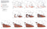
Ranching gained a hold as the first extensively practiced occupation of settlers following the purchase of the Ruperts Land Territory from the Hudson’s Bay Company in 1870. According to The Canadian Encyclopedia, “agricultural settlement ... took place primarily in the 1896–1914 period.”3 The arrival of the CPR in Calgary in 1883 spurred agricultural settlement of southern regions first, followed by the taking up of homesteads within a day’s travel of successive lines. The railways influenced rural settlement in the same way street car lines later influenced urban settlement, creating ribbon-like chains of settlers clinging to their lifeline. Imported goods to make farming possible and the export of farm products both depended on the railway.
The route of the CPR was planned to traverse a route northwest from Winnipeg through reasonably well watered, fertile land through or near Edmonton,4 and westward through the mountains. John Macoun, a botanist, began the first of five exploratory trips into the Prairies in 1872. He declared Palliser and Hind to be incorrect in their assessment of the agricultural possibilities of the southern prairies.5 His arguments helped justify the southern route of the CPR desired by the Canadian Government by the early 1880s in response to the economic threat posed by the Northern Pacific Railway being constructed within hauling distance of the international border, and by the southward looking cattlemen of southern Alberta.
Agricultural settlement began slowly in the period of 1870 to 1896 but accelerated rapidly with the development of early maturing hard spring wheat at Canadian Government research stations on the Prairies.6 This combined with an aggressive marketing campaign by the federal government and the railways that were given large portions of the better prairie soil that could be sold to pay for construction of their lines. A downturn in rainfall in southeastern Alberta led to large-scale farm abandonment in the “dirty thirties” while in central, northwestern and western parts population was steady or even increased as people sought areas where precipitation was more reliable.7
As roads improved and the internal combustion engine replaced the horse, settlement began to fill the empty spaces between the earlier railway dependent settlers. Towns that had been located at frequent short intervals on the railway lines to serve the agriculturalists began to consolidate also because of this improved transportation mode and network. Population grew from 73,022 in 1901, to 373,943 in 1911, a five times increase. A further 200,000 people were added by 1921, but because of the world-wide depression of the 1930s, it took twenty years to add the next 200,000 persons to the census rolls.8 Not all of these persons settled on farms: city populations, especially Calgary and Edmonton, also underwent great growth. There was an influx of "new blood" following the Second World War while the discovery of oil at Leduc in 1947 gave a second major leg on which the provinces economy could stand. Not that petroleum was new to the province. Earlier discoveries in Turner Valley had created much activity in an area hard hit by the depression of 1914. This new discovery however, brought a longer and more sustained period of growth. The populations of the two major cities increased by more than six times in the period 1946 to 1986.9
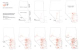
Where did they come from, these people who made Alberta their new home? Early advertising by the Department of the Interior under Clifford Sifton and later under Edmonton newspaper publisher Frank Oliver, was spread far and wide in most of the languages of Europe as well as in English. The 1911 Census of Canada, the first decennial census following the creation of the province, shows that 43.3% of the population was born in Alberta, 11.75% in England and Wales, 4.3% in Scotland, 21.7% in the United States, 5.6% in the Austro-Hungarian Empire (mainly Galicia and Bukovina10 both now part of Ukraine), 1.8% in Germany, and about 1% in Ireland.11 Among the 9.1% shown as others were people born in Scandinavian countries, Russia, France and the Netherlands. Those born in the U.S.A. included people from as near as Montana, the Dakotas and Minnesota, the northern tier States, but from further south also as in the case of special groups such as Mormons from Utah and several thousand Afro-American settlers from Oklahoma. These people were in search of cheap or free land, freedom, and greater economic opportunities common to most of those who came to Alberta and built the province.
Notes | Bibliography | Abbreviations
1. J.G. MacGregor, A History of Alberta (Edmonton: Hurtig, 1972), pp. 74 ff.2. Palmer and Palmer, p. 31.
3. The Canadian Encyclopedia, 1988, p. 51.
4. The route, as shown on Sandford Fleming’s maps (and copied by others), did not pass through the existing settlement of Edmonton, but an assumption was made that Edmonton would relocate to the railway once it was built, and a location at Hay Lakes is shown as Edmonton. Thus two Edmontons are shown on many maps. The movement of a town to a newly constructed railway was not an uncommon occurrence. An example in the Edmonton area is Stony Plain, which moved in 1905.
5. Palmer and Palmer, p. 59.
6. The Canadian Encyclopedia, p. 56.
7. Palmer and Palmer, p. 246; Atlas of Alberta, Plates 16, 18, 19, 51.
8. The Canadian Encyclopedia, p. 51.
9. B.M. Barr and P.J. Smith, eds., Environment and Economy: Essays on the Human Geography of Alberta (Edmonton: Pica Pica Press, the University of Alberta Press, 1984), p. 30; The Canadian Encyclopedia, pp. 315, 657.
10. The Canadian Encyclopedia, p. 2207.
11. Atlas of Canada (Ottawa: Department of the Interior, 1915), p. 94.