The Beginnings of the Northern Alberta Railways
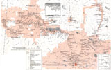
These railways played a significant role in the development of northeast Alberta, the interior of British Columbia and the Mackenzie River Basin. It was J.D. McArthur’s dream to build a “trans-prairie” railway that opened up the area, and although “in the process, he lost rail lines and a fortune, ... he left a lasting legacy.”2
Early Explorers
The earliest commercial enterprise in northern Alberta was the fur trade. Peter Pond, encouraged by the Northwest Company to explore the northwest beyond the reaches of the Churchill River system, first entered the northwest course of the Athabasca River at its confluence with the Clearwater River at the site of what is now Fort McMurray in 1778. He had portaged the height of land separating the northeasterly flowing Churchill River system from the northward flowing waters of the Clearwater-Athabasca-Mackenzie River system. This portage became known as the Methye Portage, and for almost a century it was part of the transport route for the fur trade to and from the far northwest.
Alexander Mackenzie, a partner in the Northwest Company, followed Peter Pond into this newly discovered country searching for a route to the Pacific Ocean. Mackenzie’s first journey of exploration took him to the Arctic Ocean by way of the river named in his honour. Using Fort Chipewyan on Lake Athabasca as a base, Mackenzie next headed up the Peace River in the fall of 1792. He wintered at the newly constructed Fort of Forks opposite and upstream from the present day town of Peace River before pressing on to the Pacific coast in 1793.3 Fur traders followed, and by 1805 Fort Dunvegan, Hudson’s Hope and Fort St. John had become significant trading posts. The trade penetrated west up the Parsnip River and over the height of land to the Fraser River, opening up the New Caledonia area.4 New Caledonia furs generally travelled via Peace River, but in 1826 a more practical route was established to take them to the Pacific Coast. The Peace River forts, however, continued to ship their furs east.5
Fur Trade Routes
The arrival of the steamboat S.S. Northcote at Fort Edmonton in 1875 marked the beginning of a change to the established fur trade routes to the far north.6 Initially, Fort Carlton, and later Prince Albert, benefited from the steamboat service as northern goods travelled overland to these points from the Churchill and Sturgeon-Weir Rivers to connect with the steamboat on the North Saskatchewan River.7
In 1877 a 90-mile overland trail between Fort Edmonton and Athabasca Landing opened.8 Its purpose was to provide an easier route between the Athabasca River and Fort Edmonton than the extremely difficult trail to Fort Assiniboine. The new trail immediately attracted the Peace River trade; goods from Hudson’s Hope, Fort St. John and Dunvegan travelled downstream to Peace River Landing, then overland to Grouard at the west end of Lesser Slave Lake, then east across the lake, and finally down the Lesser Slave and Athabasca Rivers to the head of the Athabasca Trail. This new route quickly became the Hudson’s Bay Company’s main access to the Peace River country.9 The trail’s location also encouraged the gradual diversion of the lower Peace and Mackenzie River traffic to Athabasca Landing and south to Fort Edmonton. Once on the North Saskatchewan River, the steamboat could carry the goods to the mouth of the river at Lake Winnipeg.
These two Hudson’s Bay Company initiatives, the introduction of steamboats to the North Saskatchewan River and the opening of the Athabasca Trail, transferred the rough east-west fur trade transport corridor from the Churchill and Sturgeon-Weir River systems to the North Saskatchewan River.
Thus Fort Edmonton became the focal point for the far northern and northwestern fur trade. The subsequent use of steamboats on the Athabasca River below Fort McMurray in 1883, on the Mackenzie River in 1884, and on the Athabasca River between Athabasca Landing and Grand Island in 1888 brought about the need to improve the Athabasca Trail to the status of a wagon road and to install, in 1889, a tramway on Grand Island to carry freight around the Grand Rapids.10 Soon after, steamboats could also be found working on the Peace River, Lesser Slave Lake, and Lesser Slave River to the rapids near its confluence with the Athabasca River, and from Athabasca Landing to Mirror Landing at the Lesser Slave River.
The completion of the CPR transcontinental line across the southern prairies in 1883 drew fur trade freight south from Edmonton via cart trail to Calgary.11 After 1883, charters were granted to other railway companies, which proposed to connect the CPR transcontinental line with Edmonton and points north, particularly Peace River and Dunvegan. Over 30 years would pass, however, before railways would replace the arduous cart trails that connected the water transportation systems in the Peace River area.
The Gold Rush
The second major commercial venture to influence the development of the north was prospecting and mining. The Klondike Gold Rush of 1897–98 drew some 2,000 gold seekers through Edmonton.12 While these adventurers were only a small fraction of the total number who sought their fortune in the Klondike, they nevertheless boosted Edmonton’s interest in the mining potential of northern Canada and, therefore, influenced transportation development in northern Alberta. Most followed the fur trade route from Edmonton via Athabasca Landing and on to the Athabasca-Mackenzie River systems. The prospectors taxed the Hudson’s Bay Company steamboat service on these river systems to capacity and drew an American company to launch a short-lived additional steamboat service on this route.13 A few gold seekers, upon reaching Athabasca Landing, travelled west to Fort Assiniboine, then proceeded overland to Lesser Slave Lake, then followed the established fur trade route to the Peace River country. From here they selected one of a number of optional courses to the Klondike.14
The trek resulted in improvements being made to the overland route. The territorial government in 1898 improved the trail from Fort Assiniboine to Lesser Slave Lake.15 The federal government in the same year appropriated money to improve the Peace River Landing-Fort St. John trail through Dunvegan.16 In the opening year of the twentieth century, a number of railway charters were granted that proposed links between Edmonton and the Yukon, or Vancouver and the Yukon, for the purpose of exploiting the mineral wealth. None of these Yukon-bound railway charters materialized to the extent that they had any influence on northern development. Although the lure of the Klondike did quickly recede, the mineral and other nonrenewable natural resources of northern Canada continued to beckon commercial interests.
Agriculture
The third major commercial development was agriculture. Very little agricultural development had taken place in the North-West Territories before 1869–70 when the Hudson’s Bay Company turned over to the young Government of Canada its claims to the northwest, officially called Rupert’s Land. As botanists and geologists associated with the railway and land surveyors assessed Canada’s vast prairie lands, the potential for agricultural development in the Peace River Country became evident.
Sandford Fleming sent out several expeditions in the 1870s to locate a route for the Pacific railway. Because the Pine River and Peace River Passes were being considered as possible outlets to the Pacific, a thorough exploration of the Peace River country was undertaken to determine its agricultural potential. An expedition under the leadership of Charles Horetsky and Professor J. Macoun in 1872 brought back favourable reports on the fertility of the country.17 Subsequent expeditions in the same decade concurred that the Peace River country had definite agricultural potential,18 although the enthusiasm expressed in these reports was later tempered somewhat. C.J. Tracie notes that John Macoun in 1875 declared that the land was “astonishingly rich.” Tracie observes that Macoun’s son James in a 1904 report cautiously suggested the need to gather more satisfactory evidence that the land was suited for the rancher or wheat grower.19 The Macouns reported differing perceptions of soil depth, stones in the soil and the amount of marshland.20 Although the valley had yielded successful cereal crops, cautions about the number of frost-free growing days on the uplands persisted.21 The Dominion government’s promotional material enthusiastically supported the Peace River country as early as 1899,22 so James Macoun was soundly admonished by northern business interests and theEdmonton Bulletin for his public uncertainty toward the area.23
Some of the earlier agricultural settlers were attracted to the western end of Lesser Slave Lake, and along the Peace River.24 By 1903 the Spirit River settlement had attracted about 20 homesteaders primarily engaged in ranching, but also cultivating about 200 acres of gardens and grain fields.25 This was one of the most prominent of several settlements that contained the ranches and gardens of half-breed settlers, the small gardens of mission settlements and white immigrants' ranches and grain farms.26 By 1905, a post office with monthly service from Peace River Crossing served Spirit River settlement,27 which was surveyed in 1907. Further south on the Grande Prairie small pockets of agricultural settlement such as that at Saskatoon Lake did exist before 1905.28
These early agricultural settlements tended to support the fur trade settlements. Their goods were shipped by way of the well-established road and river fur trade supply route. The need to transfer from one mode of transportation to another precluded using this system for carrying bulk grain shipments to a wider market. The development of a practical agricultural economy in the Peace River and Grande Prairie areas needed a railway line into the area.29
Peace River Country
While the prospect of railway building did attract settlement, neither the Grand Trunk Pacific Railway nor the Canadian Northern Railway proposals, chartered to serve the Peace River country, ever did materialize. The Grand Trunk Pacific in 1906 chose, and was granted authority, to build via the Yellowhead instead of the Pine or Peace River passes. The two Canadian Northern projects fell short of reaching the Peace River area.
Settlers nevertheless continued to be attracted to the Peace River country. Without railway access, intending settlers had to be hardy and determined just to get into the area. Considerable efforts by the federal government in 1906 and 1907 to deepen the channel in the lesser Slave River at Mirror Landing to enable steamboats to make a through trip from Athabasca Landing to the west end of Lesser Slave Lake met with failure.30 Supplies for the Peace River country continued to be transferred at Mirror Landing from steamboats to scows, then drawn upstream some 20 miles to Saulteaux Landing where they were again transferred to a lake steamer for the trip across Lesser Slave Lake.31 The province of Alberta embarked upon a program of colonization roads from Athabasca Landing to Lesser Slave Lake to help ease the several transfers from road to water to road again encountered on the trip from Edmonton to the Peace River country.32
In 1909 demand for land increased following surveying of the Peace River and Grande Prairie areas.33 The 1911 census revealed that 900 people resided in the area.34
Northern Rail Development
The arrival of the Grand Trunk Pacific transcontinental line at Edson opened up new possibilities for entering the Grande Prairie area. In 1910 the government of Alberta began work on the Edson-Grande Prairie trail. It opened for traffic in 1911.35 This trail played a significant role in the early settlement of the Grande Prairie area.
After the Province of Alberta was established in 1905, its first government, under the leadership of Premier A.C. Rutherford, passed a railway act in 190736 and announced a railway extension policy in 1909.37 Northern rail development figured prominently in that policy. Most of the northern extensions were never fully acted upon by the railways involved but an independent group of promoters did begin construction under the title of the Alberta and Great Waterways Railway. Financial irregularities in the sale of bonds for this company resulted in the fall of the Rutherford administration in 1910 and the subsequent delay of the project. In the absence of railway construction into the north country, the government had already assisted with building colonization roads into the area.
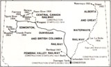
Railway construction on the first lines to penetrate significantly into northern Alberta finally began in earnest in 1912, when the Edmonton, Dunvegan and British Columbia Railway began laying its tracks toward the Peace River country, and in 1913 when the Alberta and Great Waterways Railway began work on the line toward Lac La Biche and Fort McMurray.
The Edmonton, Dunvegan and British Columbia Railway and the Central Canada Railway made significant contributions to the settlement and economy of the Peace River area. Construction deficiencies, notably the lack of gravel on the graded roadbed under the ties particularly on the Grande Prairie branch, frequently rendered parts of the line impassable for long spells during and after periods of wet weather.
The Alberta and Great Waterways Railway (A&GWR)intended to aid transportation into the far north by diverting traffic around the several rapids in the Athabasca River above Waterways, but construction delays prevented that railway from achieving its purpose for almost a decade after construction began.

In 1920 the Government of Alberta was forced to intervene. It took control of these debt-ridden, poorly maintained railways, turned the management of the Edmonton, Dunvegan and British Columbia Railway and the Central Canada Railway over to the CPR, and provided a large sum of money for the purpose of rehabilitating and extending the lines. Within two years service had improved significantly. The government operated the A&GWR directly and completed construction of the line to Waterways, and in 1926 acquired full ownership and assured operational management of all three of these northern lines. In 1927 the government completed an additional line, the Pembina Valley Railway, to serve the Barrhead area. This network of now well-maintained and well-equipped railways became attractive to prospective buyers, and in 1929 the CPR and the CNR jointly purchased and managed them under the ownership of a new company called the Northern Alberta Railways.
The Northern Alberta Railways extended its lines to reach Dawson Creek, B.C. and Hines Creek. Although it provided a reliable basic service many of its servicing facilities were quite primitive. Following the outbreak of World War II the United States government became interested in the line for strategic purposes, and frequent and long trains carrying men and supplies for the building of the Alaska Highway taxed the line to Dawson Creek. Similarly heavy traffic developed on the Waterways line to support the construction of the Canol oil pipeline. The railway emerged after the war as an efficient and modern operation. In 1958 the Pacific Great Eastern Railway connected with the NAR at Dawson Creek. In 1980, the CNR received regulatory approvals to acquire the CPR’s half of the NAR. NAR historian Ena Schneider states:38
On January 1, 1981 a new day dawned as the NAR became the Peace River Division of CN Rail’s Mountain Region.
Hitched to the CN Rail team, NAR would lose its identity and bring an era in railroading in northern Alberta to a close. Back in 1929 NAR had been the “giant” that was created from four smaller railways in a consolidation that transformed the pioneering railway into a highly successful operation both financial and in terms of its contribution to the quality of life in northern Alberta. But its frontier days were long gone and NAR was part of transcontinental railway.
Notes | Bibliography | Abbreviations
1. Ena Schneider, Ribbons of Steel: The Story of the Northern Alberta Railways (Calgary: Detselig Enterprises, 1989), p. 145.2. Ibid., p. 1.
3. F.H. Kitto, The Peace River District, Canada: Its Resources and Opportunities (Ottawa: Dept. of the Interior, 1930), p. 11.
4. Ibid.
5. E.W. Morse, Canoe Routes of the Voyageurs. The Geography and Logistics of the Canadian Fur Trade (Royal Canadian Geographical Society, 1962), pp. 38–39.
6. M. Zaslow, “A History of Transportation and Development of the Mackenzie Basin from 1871–1921” (Dissertation, University of Toronto, 1948), p. 26.
7. H.A. Innis, The Fur Trade in Canada (New Haven: Yale University Press, 1930), p. 348.
8. Athabasca Historical Society, Athabasca Landing: An Illustrated History, p. 19.
9. Ibid.
10. Edmonton Bulletin, 8 June 1889; Hudson’s Bay Co. Archives, D 25/17 fo. 305.
11. Zaslow, “A History of Transportation and Development,” p. 26.
12. Ibid., p. 44.
13. Ibid., pp. 51–52.
14. Ibid., p. 52.
15. Ibid., p. 52.
16. Ibid., p. 50.
17. Ibid., p. 13.
18. Ibid., pp. 14, 16, 18.
19. C.J. Tracie, “Land of Plenty or Poor Man’s Land,” in Images of the Plains, B.W. Blouet and M.P. Lawson, eds., (Lincoln: University of Nebraska Press, 1975), p. 115.
20. Ibid., p. 116.
21. Ibid., pp. 116–17.
22. Ibid., p. 121.
23. L.G. Thomas, The Liberal Party in Alberta (Toronto: University of Toronto Press, 1959), pp. 64–65.
24. Zaslow, “A History of Transportation and Development,” p. 80.
25. Ibid., p. 88.
26. Ibid.
27. Ibid.
28. Ibid.
29. Ibid., pp. 88, 90.
30. Ibid., p. 14.
31. Ibid., p. 140.
32. Ibid., p. 142.
33. Ibid., p. 150.
34. H.M. Leppard, “The Settlement of the Peace River Country” Geographical Review 25 (1935): 63.
35. Zaslow, “A History of Transportation and Development,” p. 245.
36. Thomas, The Liberal Party in Alberta, p. 58.
37. Ibid., p. 62.
38. Schneider, Ribbons of Steel, pp. 277–78.